
Lêer:NileDelta-EO.JPG
Geen hoër resolusie is beskikbaar nie.
NileDelta-EO.JPG (496 × 565 piksels, lêergrootte: 54 KG, MIME-tipe: image/jpeg)
Opsomming
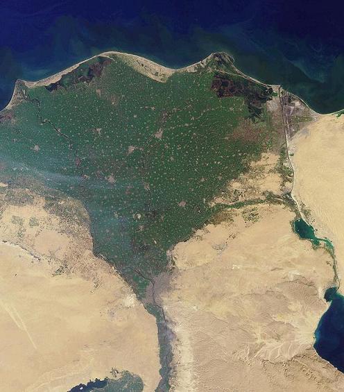
English: NASA image of Nile Delta, taken by MISR instrument on January 30, 2001. Cropped.
العربية: صورة من وكالة ناسا تُظهر منطقة دلتا النيل، أو الوجه البحري، والتي تقع في شمال مِصْر، تم التقاطها في 30 يناير 2001 م، وهي صورة مقصوصة
Polski: Delta Nilu, zdjęcie NASA zrobione przez satelitę Terra przy pomocy urządzenia MISR (ang. Multi-angle Imaging Spectro-Radiometer).
Lisensiëring
| This file is in the public domain in the United States because it was solely created by NASA. NASA copyright policy states that "NASA material is not protected by copyright unless noted". (See Template:PD-USGov, NASA copyright policy page or JPL Image Use Policy.) | ||
 |
Warnings:
|
History
| date/time | username | edit summary |
|---|---|---|
| 22:18, 12 June 2005 | Bratsche | ('sattelite' -> 'satellite'; -- <a href="/wiki/User:Humanbot" title="User:Humanbot">Join and fix more!</a>) |
| 23:15, 28 May 2005 | Pearle | (Minor category, interwiki, or template style cleanup; {{msg:foo}} -> {{foo}} conversion for MediaWiki 1.5+ compatibility) |
| 12:31, 17 December 2004 | Jpk | (+fi) |
| 04:56, 11 September 2004 | Glenn | (+da) |
| 23:44, 13 March 2004 | Seth Ilys | ({{msg:PD}} NASA image of Nile Delta, taken by <a href="/wiki/MISR" title="MISR">MISR</a> sattelite on January 30, 2001. Cropped.) |
Lêergeskiedenis
Klik op die datum/tyd om te sien hoe die lêer destyds gelyk het.
| Datum/Tyd | Duimnael | Dimensies | Gebruiker | Opmerking | |
|---|---|---|---|---|---|
| huidig | 08:59, 18 Oktober 2005 | | 496 × 565 (54 KG) | ChongDae | This image was copied from wikipedia:en. The original description was: {{PD}} NASA image of Nile Delta, taken by MISR satellite on January 30, 2001. Cropped. da:Billede:Nilens delta.jpg fi:Kuva:Niilin suisto.JPG {| border="1" ! date/time || |
Lêergebruik
Die volgende bladsy gebruik dié lêer:
Globale lêergebruik
Die volgende ander wiki's gebruik hierdie lêer:
- Gebruik in an.wikipedia.org
- Gebruik in ar.wikipedia.org
- Gebruik in ast.wikipedia.org
- Gebruik in as.wikipedia.org
- Gebruik in be.wikipedia.org
- Gebruik in br.wikipedia.org
- Gebruik in ckb.wikipedia.org
- Gebruik in co.wikipedia.org
- Gebruik in da.wikipedia.org
- Gebruik in da.wikibooks.org
- Gebruik in en.wikipedia.org
- Gebruik in en.wikibooks.org
- Gebruik in en.wiktionary.org
- Gebruik in eo.wikipedia.org
- Gebruik in es.wikipedia.org
- Gebruik in et.wikipedia.org
- Gebruik in eu.wikipedia.org
- Gebruik in ext.wikipedia.org
- Gebruik in fa.wikibooks.org
- Gebruik in fr.wikipedia.org
- Gebruik in fy.wikipedia.org
- Gebruik in gd.wikipedia.org
- Gebruik in gl.wikipedia.org
- Gebruik in ha.wikipedia.org
- Gebruik in he.wikipedia.org
- Gebruik in he.wikibooks.org
- Gebruik in he.wiktionary.org
- Gebruik in hi.wikipedia.org
- Gebruik in hr.wikipedia.org
Wys meer globale gebruik van die lêer.