
Lêer:Antarctica, Australia territorial claim.svg

Size of this PNG preview of this SVG file: 600 × 600 piksels. Ander resolusies: 240 × 240 piksels | 480 × 480 piksels | 768 × 768 piksels | 1 024 × 1 024 piksels | 2 048 × 2 048 piksels | 806 × 806 piksels.
Oorspronklike lêer (SVG-lêer, normaalweg 806 × 806 piksels, lêergrootte: 63 KG)
| Beskrywing |
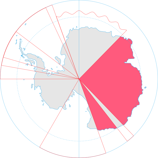
English: Map showing the territorial claim to Antarctica by the country in the filename. Also on the map are is the 60° S Parallel, Antarctic Circle, 0/180 latitude line and (in red) the borders of the claims by other states. |
| Datum | |
| Bron | Generated from Antarctica by Lokal_Profil. |
| Outeur | Lokal_Profil |
| Toestemming (Hergebruik van die lêer) |
This file is licensed under the Creative Commons Attribution-Share Alike 2.5 Generic license. Naamsvermelding: Lokal_Profil
|
Lêergeskiedenis
Klik op die datum/tyd om te sien hoe die lêer destyds gelyk het.
| Datum/Tyd | Duimnael | Dimensies | Gebruiker | Opmerking | |
|---|---|---|---|---|---|
| huidig | 17:01, 8 Mei 2020 | | 806 × 806 (63 KG) | Spesh531 | Norway's claim extends south to the South Pole as of June 12 2015. Northern claim is still undefined |
| 20:55, 30 Junie 2008 |  | 806 × 806 (65 KG) | Lokal Profil | {{Information |Description={{en|Map showing the territorial claim to Antarctica by the country in the filename. Also on the map are is the 60° S Parallel, Antarctic Circle, 0/180 latitude line and (in red) the borders of the claims by other states.}} |So |
Lêergebruik
Die volgende 2 bladsye gebruik dié lêer:
Globale lêergebruik
Die volgende ander wiki's gebruik hierdie lêer:
- Gebruik in an.wikipedia.org
- Gebruik in ar.wikipedia.org
- Gebruik in az.wikipedia.org
- Gebruik in bg.wikipedia.org
- Gebruik in br.wikipedia.org
- Gebruik in ca.wikipedia.org
- Gebruik in chr.wikipedia.org
- Gebruik in ckb.wikipedia.org
- Gebruik in cs.wikipedia.org
- Gebruik in de.wikipedia.org
- Gebruik in diq.wikipedia.org
- Gebruik in el.wikipedia.org
- Gebruik in en.wikipedia.org
- Gebruik in et.wikipedia.org
- Gebruik in fa.wikipedia.org
- Gebruik in fi.wikipedia.org
- Gebruik in frr.wikipedia.org
- Gebruik in fr.wikipedia.org
- Gebruik in fy.wikipedia.org
- Gebruik in gl.wikipedia.org
- Gebruik in gv.wikipedia.org
- Gebruik in hu.wikipedia.org
- Gebruik in id.wikipedia.org
- Gebruik in ilo.wikipedia.org
- Gebruik in it.wikipedia.org
- Gebruik in ja.wikipedia.org
Wys meer globale gebruik van die lêer.