
Lêer:Bosnia and Herzegovina topographic map.svg

Size of this PNG preview of this SVG file: 600 × 549 piksels. Ander resolusies: 262 × 240 piksels | 525 × 480 piksels | 839 × 768 piksels | 1 119 × 1 024 piksels | 2 238 × 2 048 piksels.
Oorspronklike lêer (SVG-lêer, normaalweg 600 × 549 piksels, lêergrootte: 13,95 MG)
Opsomming
| Beskrywing |
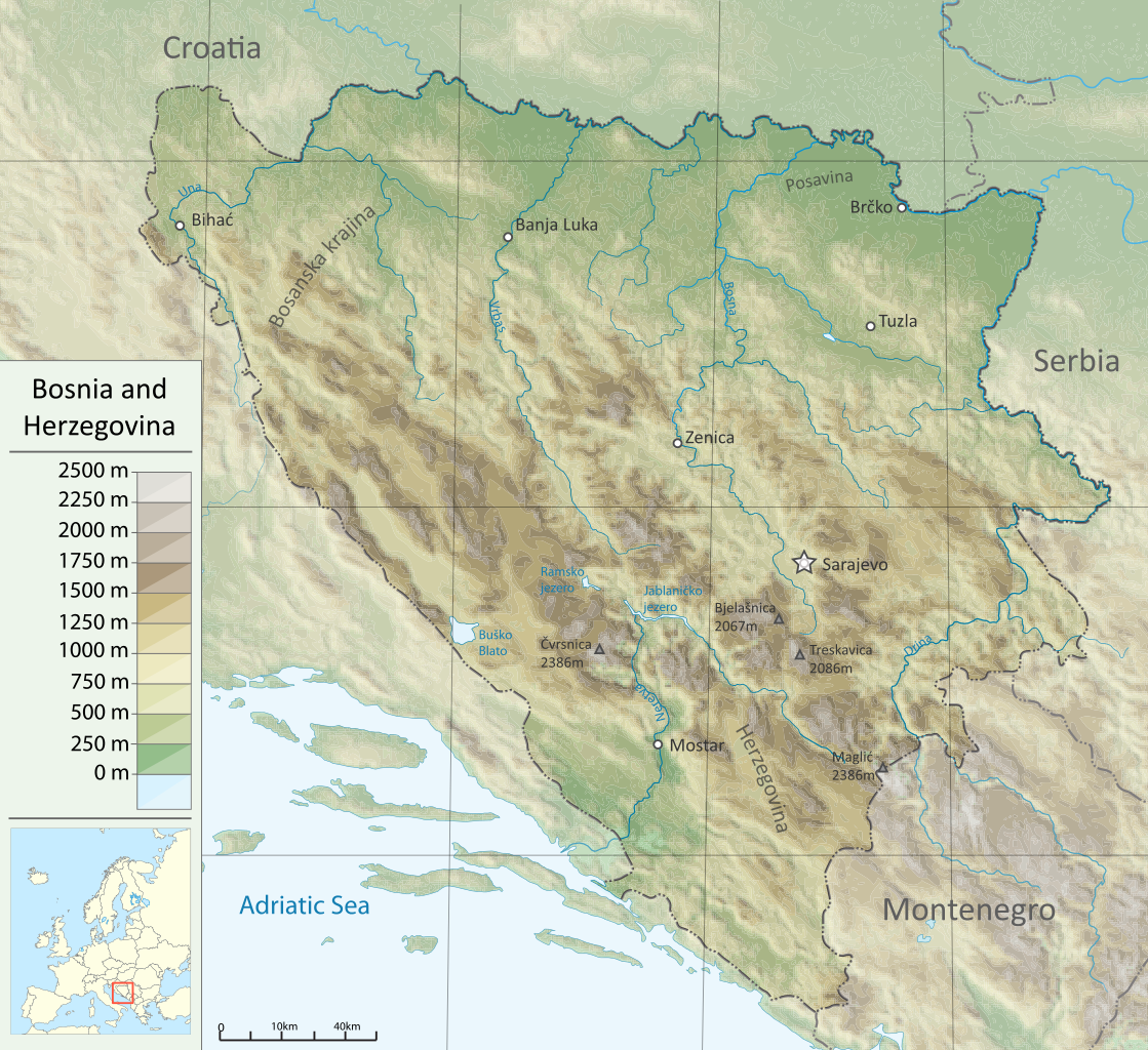
English: Topographic map of Bosnia and Herzegovina |
| Bron |
Eie werk Sources :
Software used :
|
| Outeur | DzWiki |
| Ander weergawes |
|


W3C-validity not checked.
Lisensiëring
Ek, die outeursreghouer van hierdie werk, publiseer dit onder die volgende lisensie:
Hierdie lêer is gelisensieer onder die Creative Commons Erkenning-Insgelyks Deel 3.0 Onoorgedraagde lisensie.
- U is vry:
- om te deel – die werk kopieer, versprei en deurgee
- om te hermeng – om die werk aan te pas
- Onder die volgende voorwaardes:
- naamsvermelding – U moet die nodige krediet gee, 'n skakel na die lisensie verskaf en aandui of daar veranderinge aangebring is. U mag dit op enige redelike manier doen, maar nie op enige manier wat daarop dui dat die lisensiegewer u of u gebruik onderskryf nie.
- insgelyks – As u die materiaal hermix, transformeer of voortbou, moet u u bydraes versprei onder die dieselfde of versoenbare lisensie as die oorspronklike.

|
Toestemming word verleen tot die kopiëring, verspreiding en/of wysiging van hierdie dokument onder die voorwaardes van die GNU-lisensie vir vrye dokumentasie, weergawe 1.2 of enige latere weergawe uitgegee deur die Stigting vir Vrye Sagteware, sonder Invariante Dele, geen Voorbladtekste en geen Agterbladtekste. 'n Kopie van hierdie lisensie is ingesluit in die afdeling getiteld GNU Free Documentation License. |
U kan die lisensie van u keuse kies.
Lêergeskiedenis
Klik op die datum/tyd om te sien hoe die lêer destyds gelyk het.
| Datum/Tyd | Duimnael | Dimensies | Gebruiker | Opmerking | |
|---|---|---|---|---|---|
| huidig | 17:08, 19 Desember 2011 | | 600 × 549 (13,95 MG) | DzWiki | new ver. |
| 12:56, 21 April 2011 |  | 595 × 597 (3,96 MG) | DzWiki | m | |
| 12:49, 21 April 2011 |  | 595 × 597 (4,1 MG) | DzWiki | m | |
| 15:27, 18 Maart 2011 |  | 595 × 597 (3,56 MG) | DzWiki | m | |
| 16:32, 11 Maart 2011 |  | 588 × 554 (3,49 MG) | DzWiki | {{Information |Description ={{en|1=Topographic map of Bosnia and Herzegovina}} |Source ={{own}} |Author =DzWiki |Date = |Permission = |other_versions = }} [[Category:Topographic maps of Bosnia and Herzegov |
Lêergebruik
Die volgende bladsy gebruik dié lêer:
Globale lêergebruik
Die volgende ander wiki's gebruik hierdie lêer:
- Gebruik in ar.wikipedia.org
- Gebruik in bn.wikipedia.org
- Gebruik in bs.wikipedia.org
- Gebruik in csb.wikipedia.org
- Gebruik in en.wikipedia.org
- Gebruik in fa.wikipedia.org
- Gebruik in fr.wikipedia.org
- Gebruik in hr.wikipedia.org
- Gebruik in hr.wiktionary.org
- Gebruik in hu.wikipedia.org
- Gebruik in it.wikipedia.org
- Gebruik in ja.wikipedia.org
- Gebruik in lt.wikipedia.org
- Gebruik in mzn.wikipedia.org
- Gebruik in nn.wikipedia.org
- Gebruik in rm.wikipedia.org
- Gebruik in ro.wikipedia.org
- Gebruik in sd.wikipedia.org
- Gebruik in te.wikipedia.org
- Gebruik in uk.wikipedia.org
- Gebruik in zh.wikipedia.org