
Lêer:Central African Republic Topography.png

Grootte van hierdie voorskou: 800 × 544 piksels. Ander resolusies: 320 × 218 piksels | 640 × 435 piksels | 1 024 × 696 piksels | 1 280 × 870 piksels | 1 928 × 1 311 piksels.
Oorspronklike lêer (1 928 × 1 311 piksels, lêergrootte: 3,97 MG, MIME-tipe: image/png)
Opsomming
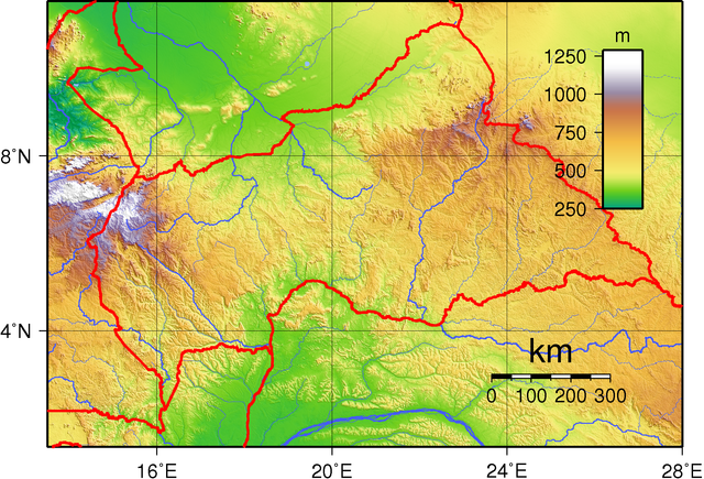
| Beskrywing | Topographic map of Central African Republic. Created with GMT from GLOBE data. |
| Datum | |
| Bron | Eie werk |
| Outeur | Sadalmelik |
Lisensiëring
| This work has been released into the public domain by its author, I, Sadalmelik. This applies worldwide. In sommige lande is dit dalk nie wettiglik moontlik nie. Indien so: I, Sadalmelik grants anyone the right to use this work for any purpose, without any conditions, unless such conditions are required by law. |
Lêergeskiedenis
Klik op die datum/tyd om te sien hoe die lêer destyds gelyk het.
| Datum/Tyd | Duimnael | Dimensies | Gebruiker | Opmerking | |
|---|---|---|---|---|---|
| huidig | 19:20, 29 Junie 2007 | | 1 928 × 1 311 (3,97 MG) | Sadalmelik | Better data/better colours |
| 13:02, 17 Junie 2007 |  | 1 955 × 1 311 (2,25 MG) | Sadalmelik | {{Information |Description= |Source=self-made |Date= |Author= Sadalmelik }} | |
| 18:00, 14 Junie 2007 |  | 1 901 × 1 319 (1,51 MG) | Sadalmelik | {{Information |Description=Topographic map of Central African Republic. Created with GMT from GLOBE data. |Source=self-made |Date=June 14, 2007 |Author= Sadalmelik }} Category:Maps of the Central African Republic [[Category:Topogr |
Lêergebruik
Die volgende bladsy gebruik dié lêer:
Globale lêergebruik
Die volgende ander wiki's gebruik hierdie lêer:
- Gebruik in als.wikipedia.org
- Gebruik in ar.wikipedia.org
- Gebruik in bg.wikipedia.org
- Gebruik in da.wikipedia.org
- Gebruik in de.wikipedia.org
- Gebruik in el.wikipedia.org
- Gebruik in en.wikipedia.org
- Gebruik in eo.wikipedia.org
- Gebruik in fa.wikipedia.org
- Gebruik in fi.wikipedia.org
- Gebruik in hu.wikipedia.org
- Gebruik in io.wikipedia.org
- Gebruik in it.wikipedia.org
- Gebruik in ka.wikipedia.org
- Gebruik in lt.wikipedia.org
- Gebruik in lv.wikipedia.org
- Gebruik in mdf.wikipedia.org
- Gebruik in ru.wikipedia.org
- Gebruik in smn.wikipedia.org
- Gebruik in tr.wikipedia.org
- Gebruik in uk.wikipedia.org
- Gebruik in vec.wikipedia.org
- Gebruik in vep.wikipedia.org