
Lêer:Fula jihad states map general c1830.png
Geen hoër resolusie is beskikbaar nie.
Fula_jihad_states_map_general_c1830.png (694 × 408 piksels, lêergrootte: 94 KG, MIME-tipe: image/png)
Opsomming
| Beskrywing |
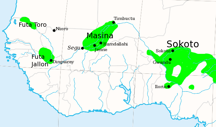
English: I made this, using the commons' en:Image:Africa_map_blank.svg as a template.
Shows the major Fula / Fulani /Peul Jihad states of West Africa, circa 1830, prior to the rise of Umar Tall. |
| Datum | 6 Julie 2007 (original upload date) |
| Bron | Transfered from en.wikipedia |
| Outeur | Original uploader was T L Miles at en.wikipedia |
| Toestemming (Hergebruik van die lêer) |
Released into the public domain (by the author). |

|
This historical map image could be re-created using vector graphics as an SVG file. This has several advantages; see Commons:Media for cleanup for more information. If an SVG form of this image is available, please upload it and afterwards replace this template with
{{vector version available|new image name}}.
It is recommended to name the SVG file “Fula jihad states map general c1830.svg”—then the template Vector version available (or Vva) does not need the new image name parameter. |
Lisensiëring
| |
This work has been released into the public domain by its author, T L Miles, at the Engels Wikipedia project. This applies worldwide. In case this is not legally possible: |
Oorspronklike oplaailogboek
The original description page was here. All following user names refer to en.wikipedia.
- 2007-07-06 20:07 T L Miles 694×408×8 (96623 bytes) I made this, using the commons' [[Image:Africa_map_blank.svg]] as a template. Shows the major Fula / Fulani /Peul Jihad states of West Africa, circa 1830, prior to the rise of Umar Tall.
Lêergeskiedenis
Klik op die datum/tyd om te sien hoe die lêer destyds gelyk het.
| Datum/Tyd | Duimnael | Dimensies | Gebruiker | Opmerking | |
|---|---|---|---|---|---|
| huidig | 15:50, 21 Desember 2007 | | 694 × 408 (94 KG) | File Upload Bot (Magnus Manske) | {{BotMoveToCommons|en.wikipedia}} {{Information |Description={{en|I made this, using the commons' en:Image:Africa_map_blank.svg as a template. Shows the major Fula / Fulani /Peul Jihad states of West Africa, circa 1830, prior to the rise of Umar Ta |
Lêergebruik
Die volgende bladsy gebruik dié lêer:
Globale lêergebruik
Die volgende ander wiki's gebruik hierdie lêer:
- Gebruik in ar.wikipedia.org
- Gebruik in azb.wikipedia.org
- Gebruik in bm.wikipedia.org
- Gebruik in ca.wikipedia.org
- Gebruik in cs.wikipedia.org
- Gebruik in cy.wikipedia.org
- Gebruik in de.wikipedia.org
- Gebruik in de.wikiversity.org
- Gebruik in en.wikipedia.org
- Gebruik in eo.wikipedia.org
- Gebruik in es.wikipedia.org
- Gebruik in ff.wikipedia.org
- Gebruik in fi.wikipedia.org
- Gebruik in fr.wikipedia.org
- Gebruik in he.wikipedia.org
Wys meer globale gebruik van die lêer.