
Lêer:New Caledonia and Vanuatu bathymetric and topographic map-fr.svg

Size of this PNG preview of this SVG file: 800 × 561 piksels. Ander resolusies: 320 × 224 piksels | 640 × 449 piksels | 1 024 × 718 piksels | 1 280 × 898 piksels | 2 560 × 1 795 piksels | 2 980 × 2 090 piksels.
Oorspronklike lêer (SVG-lêer, normaalweg 2 980 × 2 090 piksels, lêergrootte: 4,3 MG)
Opsomming
| Beskrywing |
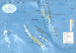
English: Bathymetric and topographic map of New Caledonia and Vanuatu, Oceania.
Note: The background map is a raster image embedded in the SVG file. Français : Carte bathymétrique et topographqiue de la Nouvelle-Calédonie et de Vanuatu, Océanie.
Note : Le fond de carte est une image bitmap embarquée dans le fichier SVG.
|
||
| Datum | ; revision 2013-12 | ||
| Bron |
Own work ;
|
||
| Outeur | Eric Gaba (Sting - fr:Sting) | ||
| Toestemming (Hergebruik van die lêer) |
|
||
| Ander weergawes |
[]
Administrative and simplified version:
|


| Kameraligging | | Hierdie en ander beelde in: OpenStreetMap |
|---|
Lisensiëring
Ek, die outeursreghouer van hierdie werk, publiseer dit onder die volgende lisensie:

|
Toestemming word verleen tot die kopiëring, verspreiding en/of wysiging van hierdie dokument onder die voorwaardes van die GNU-lisensie vir vrye dokumentasie, weergawe 1.2 of enige latere weergawe uitgegee deur die Stigting vir Vrye Sagteware, sonder Invariante Dele, geen Voorbladtekste en geen Agterbladtekste. 'n Kopie van hierdie lisensie is ingesluit in die afdeling getiteld GNU Free Documentation License. |
This file is licensed under the Creative Commons Attribution-Share Alike Attribution-Share Alike 4.0 International, 3.0 Unported, 2.5 Generic, 2.0 Generic and 1.0 Generic license.
- U is vry:
- om te deel – die werk kopieer, versprei en deurgee
- om te hermeng – om die werk aan te pas
- Onder die volgende voorwaardes:
- naamsvermelding – U moet die nodige krediet gee, 'n skakel na die lisensie verskaf en aandui of daar veranderinge aangebring is. U mag dit op enige redelike manier doen, maar nie op enige manier wat daarop dui dat die lisensiegewer u of u gebruik onderskryf nie.
- insgelyks – As u die materiaal hermix, transformeer of voortbou, moet u u bydraes versprei onder die dieselfde of versoenbare lisensie as die oorspronklike.
U kan die lisensie van u keuse kies.
Lêergeskiedenis
Klik op die datum/tyd om te sien hoe die lêer destyds gelyk het.
| Datum/Tyd | Duimnael | Dimensies | Gebruiker | Opmerking | |
|---|---|---|---|---|---|
| huidig | 17:39, 19 Desember 2013 | | 2 980 × 2 090 (4,3 MG) | Sting | Île de Sable removed (cf http://www.shom.fr/fileadmin/data-www/DMI/Communiques_de_presse/2012/COMMUNIQUE-DE-PRESSE-SANDY-ISLAND.doc) ; new elevation data used (SRTM30 Plus) |
| 03:08, 17 Februarie 2009 |  | 2 980 × 2 090 (1,47 MG) | Sting | == Summary == {{Location|18|30|00|S|166|00|00|E|scale:10000000}} <br/> {{Information |Description={{en|Bathymetric and topographic map of New Caledonia and Vanuatu, Oceania.}} {{fr|Carte bathymétrique |
Lêergebruik
Die volgende bladsy gebruik dié lêer:
Globale lêergebruik
Die volgende ander wiki's gebruik hierdie lêer:
- Gebruik in als.wikipedia.org
- Gebruik in bn.wikipedia.org
- Gebruik in cs.wikipedia.org
- Gebruik in da.wikipedia.org
- Gebruik in de.wikipedia.org
- Gebruik in en.wikipedia.org
- Gebruik in eo.wikipedia.org
- Gebruik in fr.wikipedia.org
- Gebruik in ja.wikipedia.org
- Gebruik in www.wikidata.org