
Lêer:Spreading ridges volcanoes map-en.svg

Size of this PNG preview of this SVG file: 800 × 402 piksels. Ander resolusies: 320 × 161 piksels | 640 × 322 piksels | 1 024 × 515 piksels | 1 280 × 643 piksels | 2 560 × 1 286 piksels | 4 995 × 2 510 piksels.
Oorspronklike lêer (SVG-lêer, normaalweg 4 995 × 2 510 piksels, lêergrootte: 1,29 MG)
Opsomming
| Beskrywing |
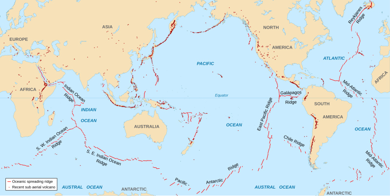
English: World map in English showing the divergent plate boundaries (OSR – Oceanic Spreading Ridges) and recent sub aerial volcanoes.
Français : Carte en anglais des dorsales océaniques et volcans terrestres récents. |
||
| Datum | 2006-10, upgraded 2015-09 | ||
| Bron |
|
||
| Outeur | Eric Gaba (Sting - fr:Sting) | ||
| Toestemming (Hergebruik van die lêer) |
|
||
| Ander weergawes |
|

The Data source link above is now dead. Potentially active/active volcanoes appear to have been mapped if erupted within about last 10,000 odd years with an accuracy of about 50 km (31 mi) onto current basemap. Some active volcanoes are not shown and divergent plate boundaries may have inaccuracies. The map has not been updated since 2015.
Lisensiëring
Ek, die outeursreghouer van hierdie werk, publiseer dit onder die volgende lisensie:
This file is licensed under the Creative Commons Attribution-Share Alike 2.5 Generic license.
- U is vry:
- om te deel – die werk kopieer, versprei en deurgee
- om te hermeng – om die werk aan te pas
- Onder die volgende voorwaardes:
- naamsvermelding – U moet die nodige krediet gee, 'n skakel na die lisensie verskaf en aandui of daar veranderinge aangebring is. U mag dit op enige redelike manier doen, maar nie op enige manier wat daarop dui dat die lisensiegewer u of u gebruik onderskryf nie.
- insgelyks – As u die materiaal hermix, transformeer of voortbou, moet u u bydraes versprei onder die dieselfde of versoenbare lisensie as die oorspronklike.
Lêergeskiedenis
Klik op die datum/tyd om te sien hoe die lêer destyds gelyk het.
| Datum/Tyd | Duimnael | Dimensies | Gebruiker | Opmerking | |
|---|---|---|---|---|---|
| huidig | 18:51, 6 September 2015 | | 4 995 × 2 510 (1,29 MG) | Sting | New background map using NGDC WCL data |
| 12:58, 11 November 2007 |  | 5 000 × 2 525 (913 KG) | Walké | petite correction | |
| 22:10, 23 Oktober 2006 |  | 5 000 × 2 525 (913 KG) | Sting | OCR name correction; + Red Sea OCR; + continent names | |
| 15:25, 23 Oktober 2006 |  | 5 000 × 2 525 (898 KG) | Sting | {{Information| |Description=World map in English showing the divergent plate boundaries (OSR – Oceanic Spreading Ridges) and recent sub aerial volcanoes |Source= '''Background map (modified) :''' Image:Tectonic plates (empty).svg created by [[User: |
.svg)
Lêergebruik
Die volgende bladsy gebruik dié lêer:
Globale lêergebruik
Die volgende ander wiki's gebruik hierdie lêer:
- Gebruik in as.wikipedia.org
- Gebruik in en.wikipedia.org
- Gebruik in en.wikiquote.org
- Gebruik in fi.wikipedia.org
- Gebruik in fr.wikipedia.org
- Gebruik in gu.wikipedia.org
- Gebruik in it.wikibooks.org
- Gebruik in ja.wikipedia.org
- Gebruik in ki.wikipedia.org
- Gebruik in lij.wikipedia.org
- Gebruik in mk.wikipedia.org
- Gebruik in ml.wikipedia.org
- Gebruik in mwl.wikipedia.org
- Gebruik in pnb.wikipedia.org
- Gebruik in pt.wikipedia.org
- Gebruik in rm.wikipedia.org
- Gebruik in sr.wikipedia.org
- Gebruik in ta.wikipedia.org
- Gebruik in te.wikipedia.org
- Gebruik in tl.wikipedia.org
- Gebruik in tr.wikipedia.org
- Gebruik in tt.wikipedia.org
- Gebruik in tyv.wikipedia.org
- Gebruik in ur.wikipedia.org
- Gebruik in vi.wikipedia.org
- Gebruik in xh.wikipedia.org